Comprehensive Survey & Mapping Services to Support Your Project from Planning to Completion. Our emphasis on clear communication and follow-through procedures ensures that client’s objectives are top priority in the planning and execution of all our processes.
Highway & Road
There are many construction project has the design has been completed available by the Professional
Engineering Support
There are many construction project has the design has been completed available by the Professional
Aerial/Drone Survey
This fast, cost-effective method delivers precise maps, 3D models, and site measurements while improving safety and reducing field time. Ideal for construction, land development, mining, and agriculture.
Construction survey
Construction surveying provides precise measurement, layout, and positioning services throughout all phases of building and infrastructure projects
Topographic
Topographic surveying is the detailed measurement and mapping of the natural and man-made features of a land surface, including elevation changes, contours, vegetation, buildings, roads, and utilities
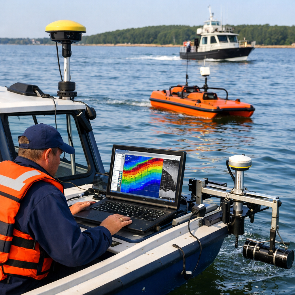
Hydrographic
Hydrographic surveying is the science of measuring and mapping underwater features, depths, and topography of water bodies including rivers, lakes, harbors, coastal areas, and ocean floors
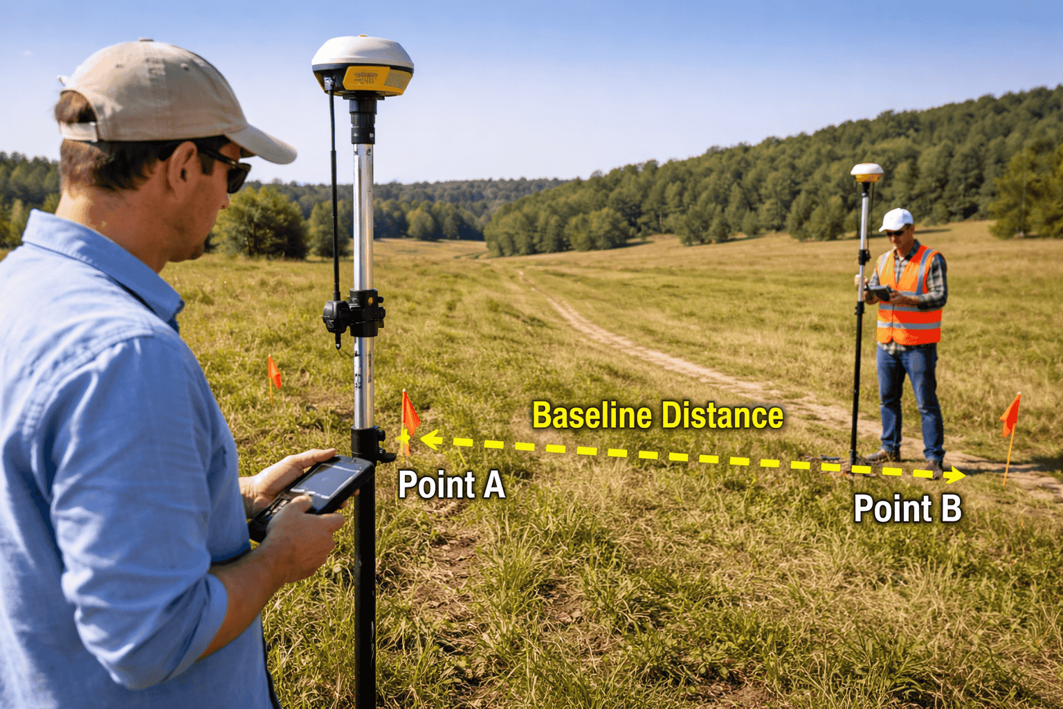
Base Line Survey
A base line survey involves establishing a straight reference line (baseline) across a survey area. This line is carefully measured and used as the primary reference for all other measurements and calculations.
A topographic survey is one of the most fundamental types of land surveying used in construction, engineering, and planning. It provides a detailed representation of the surface, including natural and man-made features, helping professionals make accurate and informed decisions.
A construction survey is a critical part of any building or infrastructure project. It ensures that structures are built in the correct location, at the right elevation, and according to the approved design. Without accurate surveying, even small errors can lead to costly mistakes and delays.
At ESCO Survey, we combine cutting-edge surveying technology with decades of industry expertise to provide comprehensive land surveying and digital mapping solutions. Whether you're planning a residential development, commercial project, highway construction, or infrastructure upgrade. Our certified surveyors deliver the precision data you need to move forward with confidence.
MD. Nurul Amin
Chairman and founder
Want to Know More?
+880 1715662699
Facts and Digits
Learn more about success
Happy Clients
3+
Project Completed
5+
Work Employed
4+
Planning Services
2+
Our Services
Services we provide
01
01
GIS Survey
A GIS survey collects and analyzes location-based data to create layered digital maps and spatial insights. It supports better planning, asset management, and decision-making across land and infrastructure projects.
A traffic survey measures vehicle flow, speed, and movement patterns on roads and intersections. The data helps in transportation planning, road safety improvements, and congestion management.
A side scan survey uses sonar technology to create detailed images of the seabed or underwater objects. It is commonly used for marine construction, pipeline inspection, and underwater hazard detection.
A utility survey identifies and maps underground and above-ground utilities such as water lines, cables, and pipelines. It reduces the risk of damage during construction and ensures safer, more efficient project execution.
Accurate and reliable survey solutions that help you collect precise field data efficiently.
Their durable, field-ready survey tools are built to perform in tough environments while boosting productivity and consistency.
Reliable survey solutions designed to deliver accurate data with ease and efficiency.
Built for real-world conditions, ensuring consistent performance and productivity in every project.
Industrial
80%
Marine Survey
88%
Construction
97%
Development Projects
72%
TESTIMONIALS
What Client Saying
I like more and more each day because it makes my life a lots of easier. They are the best and expertly trained team members who take the extra step and go the expert dynamic solutions to our customers fit changing global environment.
CEO escosurvey
Smith
I like more and more each day because it makes my life a lots of easier. They are the best and expertly trained team members who take the extra step and go the expert dynamic solutions to our customers fit changing global environment.