Understanding what lies beneath the water’s surface is crucial for industries like marine construction, offshore energy, environmental research, and archaeology. One of the most effective tools for this purpose is the side scan survey. This technology provides detailed images of the seafloor, helping professionals detect objects, map terrain, and make informed decisions.
Side Scan Survey: A Complete Guide to Mapping the Seafloor
- Home
- Side Scan Survey: A Complete Guide to Mapping the Seafloor
Side Scan Survey: A Complete Guide to Mapping the Seafloor
What is a Side Scan Survey?
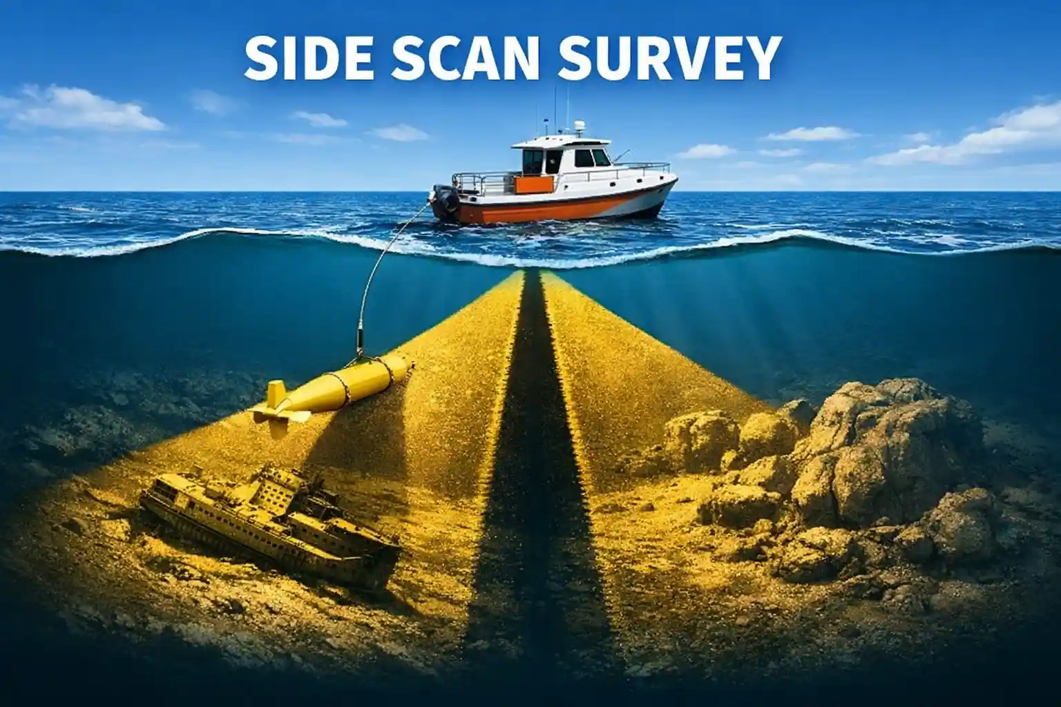
A side scan survey uses sonar technology to create high-resolution images of the seabed. Instead of measuring depth like traditional echo sounders, it focuses on capturing the texture and features of the underwater surface.
A device called a side scan sonar is either towed behind a vessel or mounted on an underwater vehicle. It emits sound waves sideways, which bounce off the seafloor and return to the sensor. These signals are then processed into detailed images.
How Does It Work?
The process is relatively straightforward:
- The sonar system emits acoustic pulses toward both sides of the survey path.
- These pulses reflect off objects and the seabed.
- The returning signals are recorded and analyzed.
- Software converts the data into grayscale images, where shadows and highlights reveal shapes and structures.
Hard objects like rocks or shipwrecks reflect stronger signals, while softer materials like mud appear darker.
Key Applications of Side Scan Surveys
1. Marine Construction
Before building bridges, ports, or offshore platforms, engineers need a clear understanding of the seabed. Side scan surveys help identify obstacles and assess ground conditions.
2. Offshore Oil & Gas
Energy companies use this method to inspect pipelines, cables, and seabed infrastructure, ensuring safe and efficient operations.
3. Underwater Archaeology
Side scan sonar is widely used to locate shipwrecks, submerged settlements, and historical artifacts.
4. Environmental Monitoring
Researchers rely on it to study seabed habitats, sediment movement, and the impact of human activities on marine ecosystems.
5. Search and Recovery Operations
It is highly effective in locating lost objects, including sunken vessels, aircraft, or debris.
Advantages of Side Scan Surveys
- High-resolution imaging of large areas
- Efficient coverage, reducing survey time
- Ability to detect small objects on the seabed
- Works in low visibility or murky water
Limitations to Consider
While powerful, side scan surveys have some limitations:
- They do not provide precise depth measurements (often paired with bathymetric surveys)
- Data interpretation requires expertise
- Performance can be affected by rough sea conditions
Side Scan vs. Other Survey Methods
- Multibeam sonar: Provides detailed depth data but less focus on texture
- Single beam sonar: Measures depth only
- Side scan sonar: Best for visualizing seabed features and objects
In many projects, these methods are combined for comprehensive results.
Conclusion
A side scan survey is an essential tool for anyone working in marine environments. From detecting underwater hazards to uncovering historical treasures, it offers a reliable and efficient way to visualize the seafloor.
As technology continues to advance, side scan surveys are becoming even more accurate and accessible—making them a cornerstone of modern hydrographic and offshore operations.